
Yes, I was in the map view, that took me to streetview.
But the Google blog should help you.
I think we are talking about different things. 😉
I don't have a problem getting to street view. It is when I'm in street view I can no longer zoom in or out inside of the 360 pic of the street. It was nice because you could zoom in to see a better detail like say a bush from the street view or zoom out to see the whole front of a big house from the street view with out traveling up or down the street. But that is ok because I read up and they no longer have that feature. 😀
Shoshone Idaho weather
<img src="http://weathersticker.wunderground.com/weathersticker/miniWeather06_both/language/www/US/ID/Gooding.gif" alt="Click for Pearce, Arizona Forecast" border="0" height="50" width="150" /></a>
Here's to all the global warming pushers, may your winters be -30 below and four feet of snow in your driveway. Because I want you happy.
-Aaron-
Posted : 01/12/2010 7:43 am
Yes, I was in the map view, that took me to streetview.
But the Google blog should help you.
One more example (sorry) 😳
If you look at the pics I took of google earth most are taken from down the street to fit the house in the pic, as before in google earth 5 you could be infront of the house and zome out and fit the whole house in the shot. 🙂
Like I did with this shot in google earth 5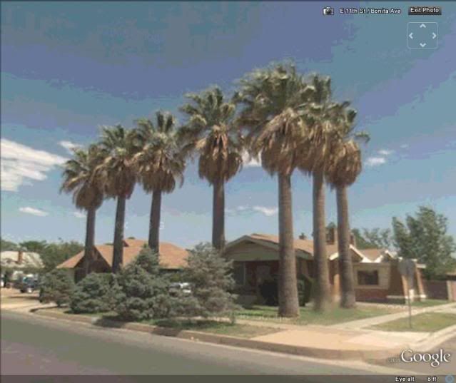
Shoshone Idaho weather
<img src="http://weathersticker.wunderground.com/weathersticker/miniWeather06_both/language/www/US/ID/Gooding.gif" alt="Click for Pearce, Arizona Forecast" border="0" height="50" width="150" /></a>
Here's to all the global warming pushers, may your winters be -30 below and four feet of snow in your driveway. Because I want you happy.
-Aaron-
Posted : 01/12/2010 7:49 am
re poverty comment:
probably why yards are gated/enclosed 😐
What is sad is that about 90% of all homes in Mexico have bars in the windows and high fences in the yard. It kind of looks like a prison no matter where you are. 😕
Shoshone Idaho weather
<img src="http://weathersticker.wunderground.com/weathersticker/miniWeather06_both/language/www/US/ID/Gooding.gif" alt="Click for Pearce, Arizona Forecast" border="0" height="50" width="150" /></a>
Here's to all the global warming pushers, may your winters be -30 below and four feet of snow in your driveway. Because I want you happy.
-Aaron-
Posted : 01/12/2010 7:59 am

Topic starter
Aaron, but with "6", last night that's how we found H's house where he grew up.
We "travelled" down the street using the streetview arrows (even though the house addresses aren't too accurate).
Found the house, as though we were standing in the middle of the street looking at it.
From that point you can "spin" your cursor "on the street" as though you are turning 360 degrees to look around, and then end up looking back at the first house.
I said to H, that looks like a little palm at the front door, so while looking at the house, I clicked the " + " at the top left of the page (or was it on the right?).
Another + click and we were close enough to see it was a trachy palm, although pic was fuzzier the closer we got.
I didn't download it, simply clicked on the demo, selected Vancouver, etc. etc.
If I knew how to do a screen capture, I could repeat it and post it here, but haven't a clue.
Yes, I noticed the bars on the windows too...scary concept if there's ever a house fire and homeowners are trapped.
High solid fences--like walls of stucco/concrete--appeal to me because of the microclimate they'd provide plants. I thought it was more for privacy, than keeping trespassers out.
Barb
<img src="http://weathersticker.wunderground.com/weathersticker/cgi-bin/banner/ban/wxBanner?bannertype=wu_bluestripes_both&airportcode=CWJV&ForcedCity=Vernon&ForcedState=Canada&wmo=71115&language=EN" alt="Find more about Weather in Vernon, CA" width="160" />
If you drink, don't drive. Don't even putt.
Posted : 01/12/2010 11:00 am
Barb,
to do a screen capture, just tap the "PrtSc" button near the upper right of your keyboard. That dumps the entire screen to the clipboard. Then, go to Start, Programs, Accessories, Paint. From the Edit menu in Paint, select "paste." You can then crop. "Paint" is a crude program, but with effort it gets the job done, marginally, and comes free with Windows.
From "File", save it with a file name you can remember and find.
You can then upload this to your Flickr account.
--Erik
Posted : 01/12/2010 12:32 pm
To make sure I did it right, I ran the procedure on "street view" for my place. The image is a little old, but you can see hay bales in the front yard. Seems to be recurring here....
<table style="width:auto;"><tr><td><a href=" http://picasaweb.google.com/lh/photo/rU0apMpP9QzJHVIfKvOyGg?feat=embedwebsit e"><img src="  " height="249" width="456" /></a></td></tr><tr><td style="font-family:arial,sans-serif; font-size:11px; text-align:right">From <a href=" http://picasaweb.google.com/terdalfarm/Fall2008?feat=embedwebsit e">Fall 2008</a></td></tr></table>
Posted : 01/12/2010 12:53 pm
Love google earth, spend most of the winter there. I also like to look around the would at all the houses. 😀
Funny you say that..I feel the same way. I love to see the commonalities and contrasts in housing and landscaping trends around the world.....You guys see the 360 cities app on google earth?? Totally cool and growing each day....
Mike Trautner
<img src="http://weathersticker.wunderground.com/weathersticker/big2_both_cond/language/www/US/NJ/Audubon.gif" alt="Click for Audubon, New Jersey Forecast" border="0" height="60" width="468" /></a>
Posted : 01/12/2010 1:33 pm
Topic starter
Practicing screen capture:
Middle house (green one) was where H spent his early years:
<iframe width="425" height="350" frameborder="0" scrolling="no" marginheight="0" marginwidth="0" src=" http://maps.google.ca/maps?client=firefox-a&channel=s&hl=en&ie=UTF8&q=bc&fb=1&gl=ca&ei=MZv1TLnlPIWisQO4ge24Cw&oi=local_group&ved=0CAYQtgMwCQ&sll=49.26844,-122.975112&sspn=0.001181,0.002382&rq=1&ev=p&split=1&radius=0.06&hq=bc&hnear=&ll=49.912972,-119.442017&spn=0.001188,0.002382&layer=c&cbll=49.268001,-122.974428&panoid=9i0ubio7OTeLZj8t3JjXeg&cbp=12,14.82,,0,17.43&source=embed&output=svembe d"></iframe>
<small><a href=" http://maps.google.ca/maps?client=firefox-a&channel=s&hl=en&ie=UTF8&q=bc&fb=1&gl=ca&ei=MZv1TLnlPIWisQO4ge24Cw&oi=local_group&ved=0CAYQtgMwCQ&sll=49.26844,-122.975112&sspn=0.001181,0.002382&rq=1&ev=p&split=1&radius=0.06&hq=bc&hnear=&ll=49.912972,-119.442017&spn=0.001188,0.002382&layer=c&cbll=49.268001,-122.974428&panoid=9i0ubio7OTeLZj8t3JjXeg&cbp=12,14.82,,0,17.43&source=embed" style="color:#0000FF;text-align:left">View Larger Map</a></small>
Practicing full view of where H was raised:
<iframe width="425" height="350" frameborder="0" scrolling="no" marginheight="0" marginwidth="0" src=" http://maps.google.ca/maps?client=firefox-a&channel=s&hl=en&ie=UTF8&q=bc&fb=1&gl=ca&ei=MZv1TLnlPIWisQO4ge24Cw&oi=local_group&ved=0CAYQtgMwCQ&sll=49.26844,-122.975112&sspn=0.001181,0.002382&rq=1&ev=p&split=1&radius=0.06&hq=bc&hnear=&ll=49.912972,-119.442017&spn=0.001188,0.002382&layer=c&cbll=49.268002,-122.974271&panoid=gt0A0g5QTIn9uelzrSNA_w&cbp=12,0,,0,5&source=embed&output=svembe d"></iframe>
<small><a href=" http://maps.google.ca/maps?client=firefox-a&channel=s&hl=en&ie=UTF8&q=bc&fb=1&gl=ca&ei=MZv1TLnlPIWisQO4ge24Cw&oi=local_group&ved=0CAYQtgMwCQ&sll=49.26844,-122.975112&sspn=0.001181,0.002382&rq=1&ev=p&split=1&radius=0.06&hq=bc&hnear=&ll=49.912972,-119.442017&spn=0.001188,0.002382&layer=c&cbll=49.268002,-122.974271&panoid=gt0A0g5QTIn9uelzrSNA_w&cbp=12,0,,0,5&source=embed" style="color:#0000FF;text-align:left">View Larger Map</a></small>
Now trying to Zoom into the little palm tree beside front steps.
<iframe width="425" height="350" frameborder="0" scrolling="no" marginheight="0" marginwidth="0" src=" http://maps.google.ca/maps?client=firefox-a&channel=s&hl=en&ie=UTF8&q=bc&fb=1&gl=ca&ei=MZv1TLnlPIWisQO4ge24Cw&oi=local_group&ved=0CAYQtgMwCQ&sll=49.26844,-122.975112&sspn=0.001181,0.002382&rq=1&ev=p&split=1&radius=0.06&hq=bc&hnear=&ll=49.912972,-119.442017&spn=0.001188,0.002382&layer=c&cbll=49.268002,-122.974271&panoid=gt0A0g5QTIn9uelzrSNA_w&cbp=12,4.68,,3,0.68&source=embed&output=svembe d"></iframe>
<small><a href=" http://maps.google.ca/maps?client=firefox-a&channel=s&hl=en&ie=UTF8&q=bc&fb=1&gl=ca&ei=MZv1TLnlPIWisQO4ge24Cw&oi=local_group&ved=0CAYQtgMwCQ&sll=49.26844,-122.975112&sspn=0.001181,0.002382&rq=1&ev=p&split=1&radius=0.06&hq=bc&hnear=&ll=49.912972,-119.442017&spn=0.001188,0.002382&layer=c&cbll=49.268002,-122.974271&panoid=gt0A0g5QTIn9uelzrSNA_w&cbp=12,4.68,,3,0.68&source=embed" style="color:#0000FF;text-align:left">View Larger Map</a></small>
That zoom was way too fuzzy, backing up a bit to try and show the little palm:
<iframe width="425" height="350" frameborder="0" scrolling="no" marginheight="0" marginwidth="0" src=" http://maps.google.ca/maps?client=firefox-a&channel=s&hl=en&ie=UTF8&q=bc&fb=1&gl=ca&ei=MZv1TLnlPIWisQO4ge24Cw&oi=local_group&ved=0CAYQtgMwCQ&sll=49.26844,-122.975112&sspn=0.001181,0.002382&rq=1&ev=p&split=1&radius=0.06&hq=bc&hnear=&ll=49.912972,-119.442017&spn=0.001188,0.002382&layer=c&cbll=49.268002,-122.974271&panoid=gt0A0g5QTIn9uelzrSNA_w&cbp=12,5.65,,1,-1.02&source=embed&output=svembe d"></iframe>
<small><a href=" http://maps.google.ca/maps?client=firefox-a&channel=s&hl=en&ie=UTF8&q=bc&fb=1&gl=ca&ei=MZv1TLnlPIWisQO4ge24Cw&oi=local_group&ved=0CAYQtgMwCQ&sll=49.26844,-122.975112&sspn=0.001181,0.002382&rq=1&ev=p&split=1&radius=0.06&hq=bc&hnear=&ll=49.912972,-119.442017&spn=0.001188,0.002382&layer=c&cbll=49.268002,-122.974271&panoid=gt0A0g5QTIn9uelzrSNA_w&cbp=12,5.65,,1,-1.02&source=embed" style="color:#0000FF;text-align:left">View Larger Map</a></small>
Still not crisp and clear, but when I'm viewing in Google Maps (yup, maps, with the built-in streetview) it's crisp and clear until I try to download the HTML here: oh well. It's the first plant to the right of the front stairs...young Trachy.!
Too bad none reproduced clearly here on PN.
...will get the hang of this eventually!
Barb
<img src="http://weathersticker.wunderground.com/weathersticker/cgi-bin/banner/ban/wxBanner?bannertype=wu_bluestripes_both&airportcode=CWJV&ForcedCity=Vernon&ForcedState=Canada&wmo=71115&language=EN" alt="Find more about Weather in Vernon, CA" width="160" />
If you drink, don't drive. Don't even putt.
Posted : 01/12/2010 2:42 pm
Barb,
Go to the top left to file, go to save, then go to save image. 😉
Shoshone Idaho weather
<img src="http://weathersticker.wunderground.com/weathersticker/miniWeather06_both/language/www/US/ID/Gooding.gif" alt="Click for Pearce, Arizona Forecast" border="0" height="50" width="150" /></a>
Here's to all the global warming pushers, may your winters be -30 below and four feet of snow in your driveway. Because I want you happy.
-Aaron-
Posted : 01/12/2010 5:01 pm
Oh! A much better/easier solution than my crude method.
Posted : 01/12/2010 5:12 pm
Funny you say that..I feel the same way. I love to see the commonalities and contrasts in housing and landscaping trends around the world.....You guys see the 360 cities app on google earth?? Totally cool and growing each day....
So far I think my favorite place on goole earth is the islands to the east of Italy, just awesome. 8)
360 cities on google earth is cool. 🙂
Shoshone Idaho weather
<img src="http://weathersticker.wunderground.com/weathersticker/miniWeather06_both/language/www/US/ID/Gooding.gif" alt="Click for Pearce, Arizona Forecast" border="0" height="50" width="150" /></a>
Here's to all the global warming pushers, may your winters be -30 below and four feet of snow in your driveway. Because I want you happy.
-Aaron-
Posted : 01/12/2010 5:20 pm
Oh! A much better/easier solution than my crude method.
I know what you mean, I was doing it some other way also until I found that. 😆
Shoshone Idaho weather
<img src="http://weathersticker.wunderground.com/weathersticker/miniWeather06_both/language/www/US/ID/Gooding.gif" alt="Click for Pearce, Arizona Forecast" border="0" height="50" width="150" /></a>
Here's to all the global warming pushers, may your winters be -30 below and four feet of snow in your driveway. Because I want you happy.
-Aaron-
Posted : 01/12/2010 5:22 pm
Topic starter
TESTING SCREEN SHOT:
<iframe width="425" height="350" frameborder="0" scrolling="no" marginheight="0" marginwidth="0" src=" http://maps.google.com/maps?t=h&hl=en&ie=UTF8&ll=33.455714,-112.118893&spn=0.000868,0.001717&z=20&layer=c&cbll=33.455714,-112.118893&panoid=cKdnm5RlW2UFX2PO80DnSQ&cbp=13,216.8,,1,2.42&source=embed&output=svembe d"></iframe>
<small><a href=" http://maps.google.com/maps?t=h&hl=en&ie=UTF8&ll=33.455714,-112.118893&spn=0.000868,0.001717&z=20&layer=c&cbll=33.455714,-112.118893&panoid=cKdnm5RlW2UFX2PO80DnSQ&cbp=13,216.8,,1,2.42&source=embed" style="color:#0000FF;text-align:left">View Larger Map</a></small>
<img src="http://weathersticker.wunderground.com/weathersticker/cgi-bin/banner/ban/wxBanner?bannertype=wu_bluestripes_both&airportcode=CWJV&ForcedCity=Vernon&ForcedState=Canada&wmo=71115&language=EN" alt="Find more about Weather in Vernon, CA" width="160" />
If you drink, don't drive. Don't even putt.
Posted : 02/12/2010 11:16 am
Barb,
looks great!
This winter, when we have time, we can all go palm hunting.
--Erik
Posted : 02/12/2010 12:11 pm
Barb that is nice. How did you get it to work like that? And yes map view works like I like it, I hope to get it fixed. 😀
Shoshone Idaho weather
<img src="http://weathersticker.wunderground.com/weathersticker/miniWeather06_both/language/www/US/ID/Gooding.gif" alt="Click for Pearce, Arizona Forecast" border="0" height="50" width="150" /></a>
Here's to all the global warming pushers, may your winters be -30 below and four feet of snow in your driveway. Because I want you happy.
-Aaron-
Posted : 02/12/2010 12:23 pm
