It snowed -- UPDATE!
Moderators: Laaz, lucky1, Alchris, Kansas, Wes North Van
It snowed -- UPDATE!
Woke up to snow this morning. Ugh!!
Last edited by wxman on Tue Apr 19, 2011 3:49 pm, edited 1 time in total.
<object width="290" height="130"><param name="movie" value="http://www.wunderground.com/swf/pws_min ... sh&lang=EN" /><embed src="http://www.wunderground.com/swf/pws_min ... sh&lang=EN" type="application/x-shockwave-flash" width="290" height="130" /></object>
that blows! and your temp is currently reading 32F.....not good!
<a href="http://www.wunderground.com/US/MA/Seeko ... igwx"><img src="http://weathersticker.wunderground.com/ ... eekonk.gif" alt="Click for Seekonk, Massachusetts Forecast" border="0" height="60" width="468" />
-
- Seedling
- Posts: 148
- Joined: Wed Apr 29, 2009 4:17 pm
- Location: MN, zone 4b/5a and Cape Coral FL (coastal), zone 10b
Looks like this Tuesday night storm forecast keeps shifting east and a little more south. We now look to get a dusting to 1.5" max here but southeastern MN and about all of central WI look to get clobbered. 6" plus! I hope you luck out Wxman, but if I were you I'd get a couple bungee cords and tie up your palm's fronds and then throw a garbage bag over them, just overnight. All that wet snow can weigh them down pretty bad. Mine took a foot of wet snow back in November and I was amazed they sprang back and didn't get any broken fronds. All that surface area to catch the snow...
Big thunderstorms coming for you down there Jim?
Yea,
We got an inch of hail this morning/pea to marble sized.
Some damage to the foliage but more of a problem
is the chilly runoff from it(hail) filling all the wells around the plants-
not doing the ground temps any favors!
We got an inch of hail this morning/pea to marble sized.
Some damage to the foliage but more of a problem
is the chilly runoff from it(hail) filling all the wells around the plants-
not doing the ground temps any favors!
<img src="http://weathersticker.wunderground.com/ ... rfield.gif" alt="Click for Fairfield, Iowa Forecast" border="0" height="60" width="468" />
2 inches on the ground and still coming down. Here we go again ...
<object width="290" height="130"><param name="movie" value="http://www.wunderground.com/swf/pws_min ... sh&lang=EN" /><embed src="http://www.wunderground.com/swf/pws_min ... sh&lang=EN" type="application/x-shockwave-flash" width="290" height="130" /></object>
-
- Arctic Palm Plantation
- Posts: 11325
- Joined: Sun Feb 18, 2007 7:31 pm
- Location: Vernon BC, Zone 5a or 5b (close to 6A!)
Holy cow Tim.
Hope it moves through quickly.
thank goodness those nanners are covered.
Barb
Hope it moves through quickly.
thank goodness those nanners are covered.
Barb
<img src="http://weathersticker.wunderground.com/ ... anguage=EN" alt="Find more about Weather in Vernon, CA" width="160" />
If you drink, don't drive. Don't even putt.
lucky1 wrote:Holy cow Tim.
Hope it moves through quickly.
Barb
That's the problem Barb
It has been cold up there for weeks...no 60(f) weather,then 70 and 80
and then back to cold and snow-maybe by next week they start to see spring like
weather but I think it's still below avg is it not Tim?
They are saying 80(f)+ here by early next week with severe weather.
if it ain't one thing........
<img src="http://weathersticker.wunderground.com/ ... rfield.gif" alt="Click for Fairfield, Iowa Forecast" border="0" height="60" width="468" />
-
- Arctic Palm Plantation
- Posts: 11325
- Joined: Sun Feb 18, 2007 7:31 pm
- Location: Vernon BC, Zone 5a or 5b (close to 6A!)
...a lousy spring sure makes summer shorter.
When/if it arrives.
When/if it arrives.
<img src="http://weathersticker.wunderground.com/ ... anguage=EN" alt="Find more about Weather in Vernon, CA" width="160" />
If you drink, don't drive. Don't even putt.
Update -- MORE PICS from another snowfall.
Had snow/sleet/thunder today and it's currently 32.7F out. Normal high is 55F!!!! Normal low is 36F!!!
<object width="290" height="130"><param name="movie" value="http://www.wunderground.com/swf/pws_min ... sh&lang=EN" /><embed src="http://www.wunderground.com/swf/pws_min ... sh&lang=EN" type="application/x-shockwave-flash" width="290" height="130" /></object>
-
- Arctic Palm Plantation
- Posts: 11325
- Joined: Sun Feb 18, 2007 7:31 pm
- Location: Vernon BC, Zone 5a or 5b (close to 6A!)
and now freezing rain on top...
Jeez, Tim, pour yourself a double.
Barb
Jeez, Tim, pour yourself a double.
Barb
<img src="http://weathersticker.wunderground.com/ ... anguage=EN" alt="Find more about Weather in Vernon, CA" width="160" />
If you drink, don't drive. Don't even putt.
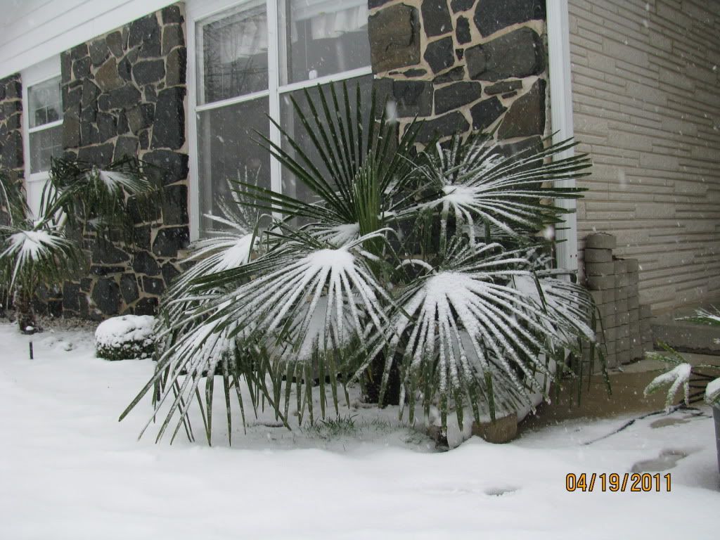
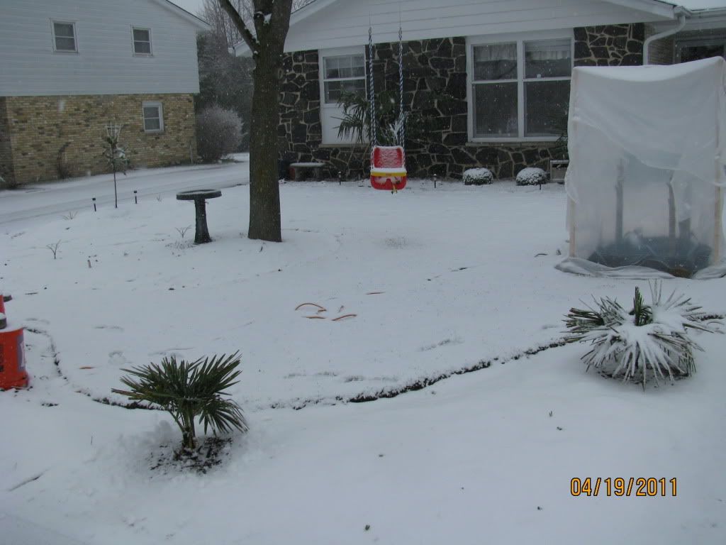
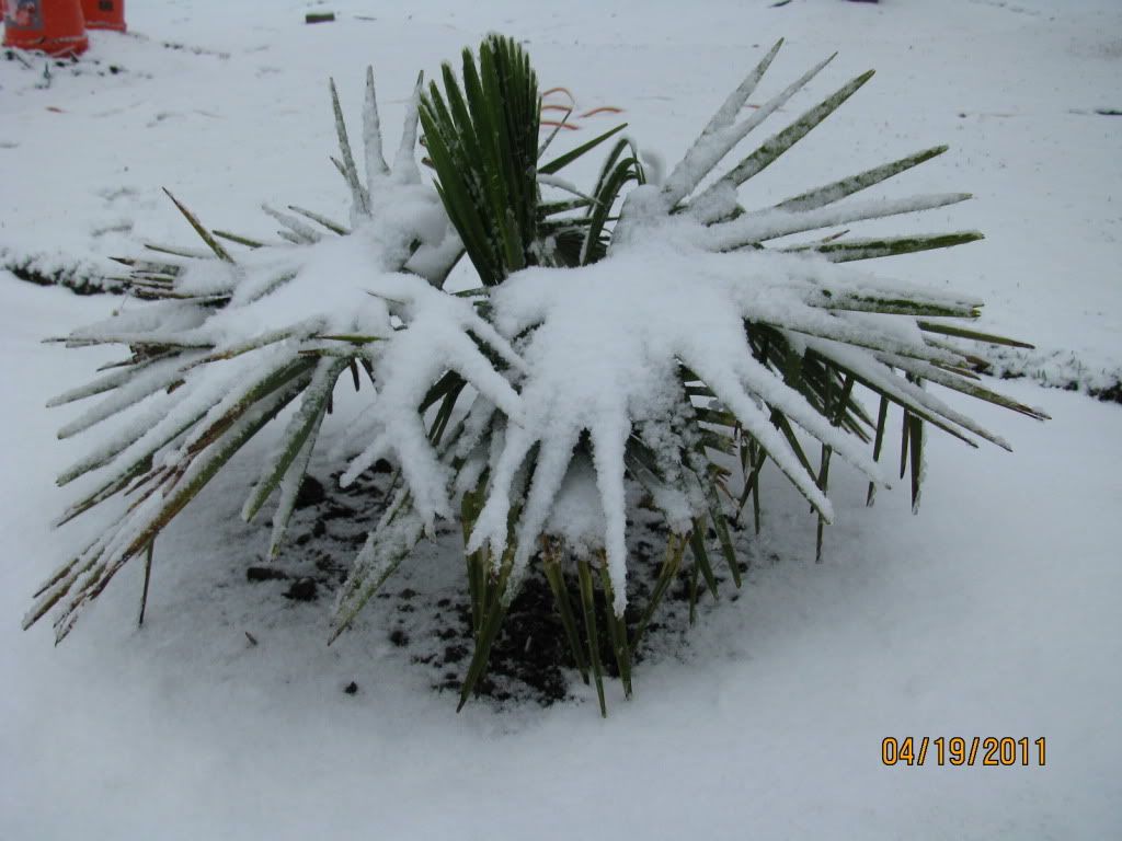
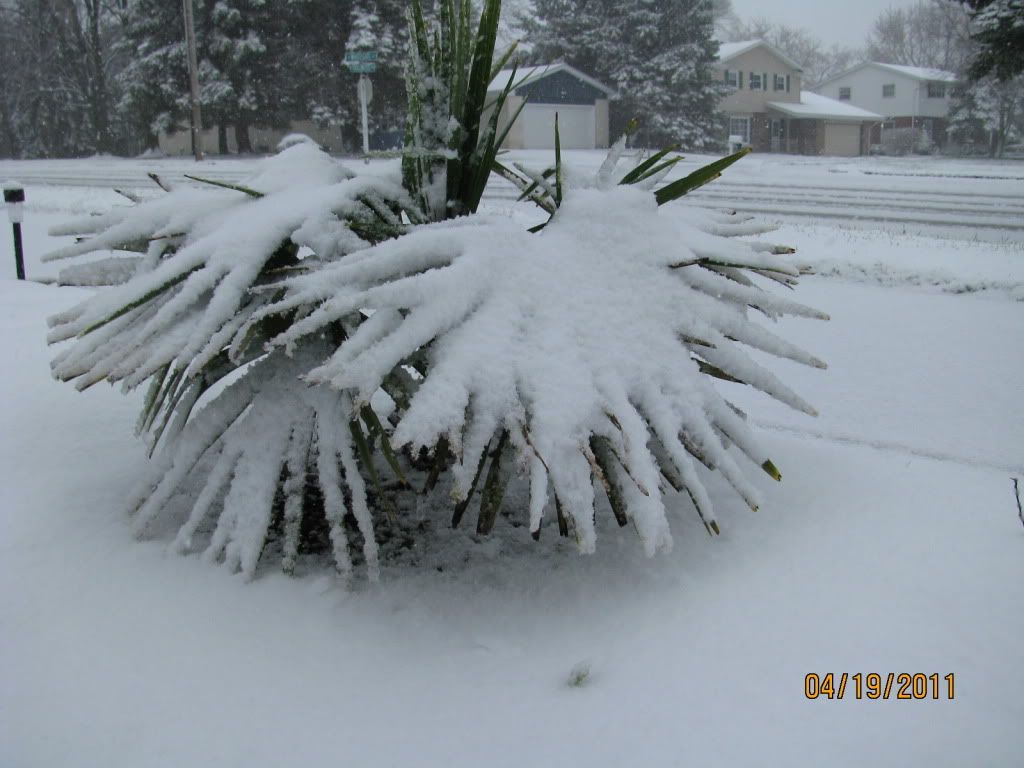
Can my trachys handle this or am I gonna have fungus/spear pull/dead fronds/other ugly stuff? Here's my forecast:
Tonight: Rain, snow, and sleet, becoming all snow after 1am. Some thunder is also possible. Low around 33. Breezy, with a northeast wind between 15 and 20 mph, with gusts as high as 30 mph. Chance of precipitation is 100%. Total nighttime snow and sleet accumulation of less than a half inch possible.
Wednesday: A 30 percent chance of snow, mainly before 1pm. Cloudy, with a high near 37. North wind around 10 mph.
Wednesday Night: Patchy fog after 4am. Otherwise, cloudy, then gradually becoming partly cloudy, with a low around 28. West wind between 5 and 10 mph.
Thursday: Patchy fog before 7am. Otherwise, mostly sunny, with a high near 46. Calm wind becoming southeast between 5 and 10 mph.
Thursday Night: A chance of rain before 1am, then a chance of rain and snow. Mostly cloudy, with a low around 32. East wind around 10 mph. Chance of precipitation is 40%.
Friday: Rain and snow showers likely, becoming all rain after 10am. Some thunder is also possible. Cloudy, with a high near 45. East wind between 10 and 15 mph, with gusts as high as 25 mph. Chance of precipitation is 70%. Little or no snow accumulation expected.
Friday Night: Showers likely. Mostly cloudy, with a low around 38. East wind 5 to 15 mph becoming southwest. Chance of precipitation is 60%. New rainfall amounts of less than a tenth of an inch possible.
Saturday: A 20 percent chance of showers. Mostly cloudy, with a high near 54. West wind between 10 and 15 mph.
Saturday Night: A 30 percent chance of showers. Mostly cloudy, with a low around 36.
Sunday: Mostly sunny, with a high near 56.
Sunday Night: A 30 percent chance of showers. Partly cloudy, with a low around 39.
Monday: A 50 percent chance of showers and thunderstorms. Mostly cloudy, with a high near 59.
Monday Night: A 50 percent chance of showers and thunderstorms. Cloudy, with a low around 47.
Tuesday: A 40 percent chance of showers and thunderstorms. Mostly cloudy and windy, with a high near 68.
So it gets better in a few days.
<object width="290" height="130"><param name="movie" value="http://www.wunderground.com/swf/pws_min ... sh&lang=EN" /><embed src="http://www.wunderground.com/swf/pws_min ... sh&lang=EN" type="application/x-shockwave-flash" width="290" height="130" /></object>
-
- Arctic Palm Plantation
- Posts: 11325
- Joined: Sun Feb 18, 2007 7:31 pm
- Location: Vernon BC, Zone 5a or 5b (close to 6A!)
Far too much moisture at low temps.
It's a crap shoot.
Barb
It's a crap shoot.
Barb
<img src="http://weathersticker.wunderground.com/ ... anguage=EN" alt="Find more about Weather in Vernon, CA" width="160" />
If you drink, don't drive. Don't even putt.
-
- Seedling
- Posts: 148
- Joined: Wed Apr 29, 2009 4:17 pm
- Location: MN, zone 4b/5a and Cape Coral FL (coastal), zone 10b
Here's what I was talking about in my previous post. This is preventative... 44 degrees here and dry still as of 6:47PMCST Tuesday evening. We still look to get an inch or so out of this but I wanted to be on the safe side in case it is more. fronds tied up with tie-downs and garbage bags over them. It's not the cold or snow, these trachies are bullet-proof, it's the snow weight I want to avoid at this point. Bring it on! Give us a foot of snow, they will be fine now... I'll uncover in the morning. low will be just at or about freezing and should be our last frost/freeze according to the outlook. Bananas go in on Easter Sunday. Good luck Wxman, you have been getting SCREWED as far as weather goes and you deserve a break.
<img src=http://i729.photobucket.com/albums/ww29 ... C_0150.jpg>
-
- Arctic Palm Plantation
- Posts: 11325
- Joined: Sun Feb 18, 2007 7:31 pm
- Location: Vernon BC, Zone 5a or 5b (close to 6A!)
Good technique, mnpalms.
Keeping moisture off the growing bud is critical as long as airflow can be maintained in the area.
I don't know if I would do that on a palm that has an inch of snow on it though.
Should wait until it melts/dries.
Barb
Keeping moisture off the growing bud is critical as long as airflow can be maintained in the area.
I don't know if I would do that on a palm that has an inch of snow on it though.
Should wait until it melts/dries.
Barb
<img src="http://weathersticker.wunderground.com/ ... anguage=EN" alt="Find more about Weather in Vernon, CA" width="160" />
If you drink, don't drive. Don't even putt.
-
- Seedling
- Posts: 148
- Joined: Wed Apr 29, 2009 4:17 pm
- Location: MN, zone 4b/5a and Cape Coral FL (coastal), zone 10b
Well we ended up with just a dusting from this system and the low was 33.8f. I guess I over-reacted by covering my palms. I just wanted to do it before it started (rain/snow) for the exact reason Barb mentioned in her last post. Unfortunately I think it was a little late for Wxman to use this covering method though, bummer. Our local news stations were crying wolf all week about this storm only to back off at the last minute. Typical...
Wxman- I'd get out there this morning and carefully brush all the snow off and they should spring back up just fine. Looks like the weather finally breaks after today (Wednesday). Upper 40s here today with one more low of 33 tonight, then lows looking to not get under about 40. Then 50s highs for a couple days and 60 by Saturday and mid 60s on Easter which is about average for this time of year. Then the following week looks great with some 70s even in the forecast with upper 40s lows. Finally!
LOL. Should almost be at my last average freeze! April 21-30 here.
<object width="290" height="130"><param name="movie" value="http://www.wunderground.com/swf/pws_min ... sh&lang=EN" /><embed src="http://www.wunderground.com/swf/pws_min ... sh&lang=EN" type="application/x-shockwave-flash" width="290" height="130" /></object>
They can take it.
Just gotta make it a few more days and it's
back to more spring like temps.
I am just happy it has stayed above freezing here...
tonights the last cold night and they are saying 38F
much better than the 33F they were saying a few days ago.
To much tender stuff in the ground!
Barb
Anything with leaves on it was shredded except the palms,
one of the T.ferns had a new croziers snapped in half by a
frozen marble but I will take that over 20sF temps.
<img src="http://weathersticker.wunderground.com/ ... rfield.gif" alt="Click for Fairfield, Iowa Forecast" border="0" height="60" width="468" />
-
- Arctic Palm Plantation
- Posts: 11325
- Joined: Sun Feb 18, 2007 7:31 pm
- Location: Vernon BC, Zone 5a or 5b (close to 6A!)
Sure they can take it but it's still a shock for them nevertheless.
Duration of cold/wet has more of an impact than a sudden one night drop in temps.
People in Florida prove that every winter.
The T fern with the snapped crozier will likely put out two, making it more bushy.
The Sequoia probably loved that hailstorm.
Barb
Duration of cold/wet has more of an impact than a sudden one night drop in temps.
People in Florida prove that every winter.
The T fern with the snapped crozier will likely put out two, making it more bushy.
The Sequoia probably loved that hailstorm.
Barb
<img src="http://weathersticker.wunderground.com/ ... anguage=EN" alt="Find more about Weather in Vernon, CA" width="160" />
If you drink, don't drive. Don't even putt.
The frond was severed completely / half way down
on the T.fern...so it will just be shorter-
In the case of the Colocasia(s) and the small E.glaucum,
Brugs,T.ferns,Bananas,Cannas and Hosta.....
much better to have 3-4 nights of 34-38F then one of 27F...
that would nuke some of them at their small size.
Weather gets better from here,lows in the 40-50s and highs
moving from 50s-60s-70s every couple days!
<img src="http://weathersticker.wunderground.com/ ... rfield.gif" alt="Click for Fairfield, Iowa Forecast" border="0" height="60" width="468" />
Who is online
Users browsing this forum: Google [Bot] and 3 guests